Day 4 · Clusters — Where Bangladesh gathers: crowding, leaving and the missing men
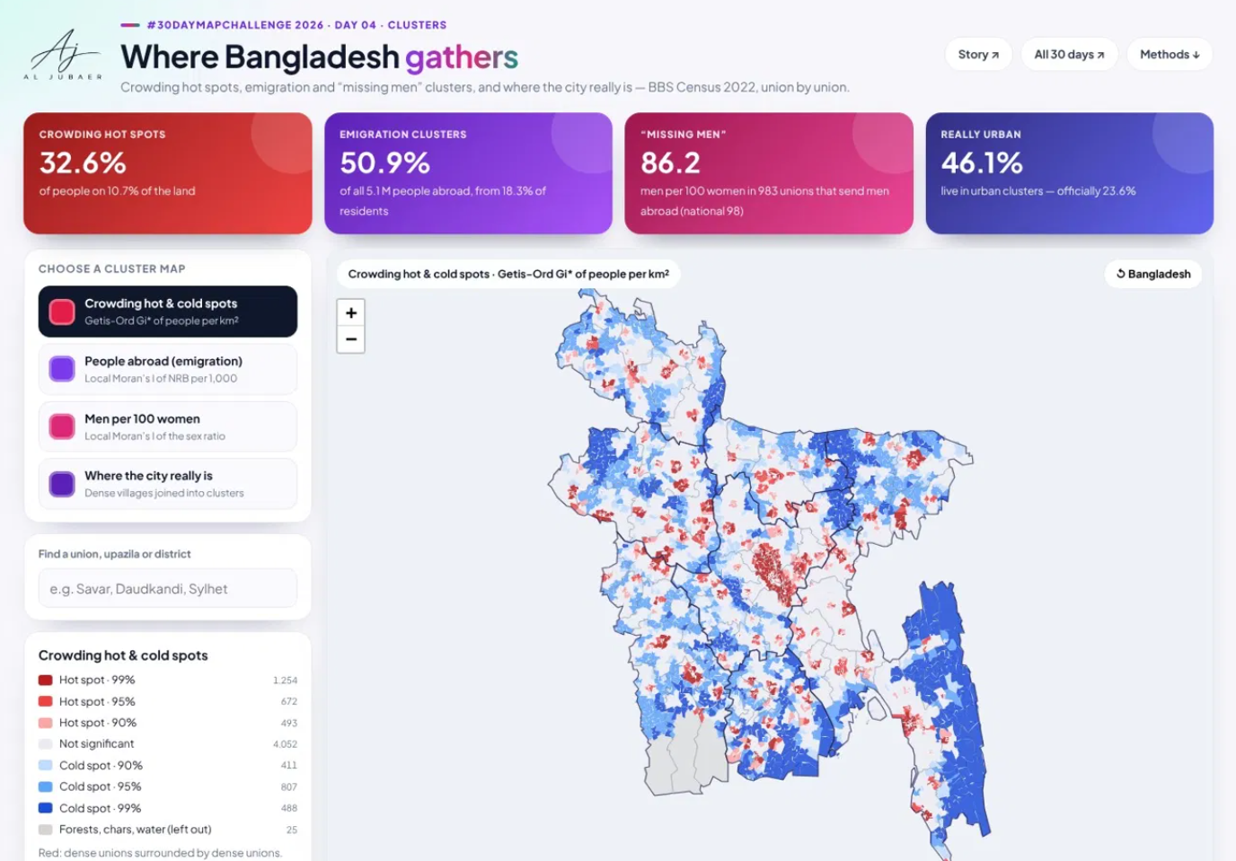
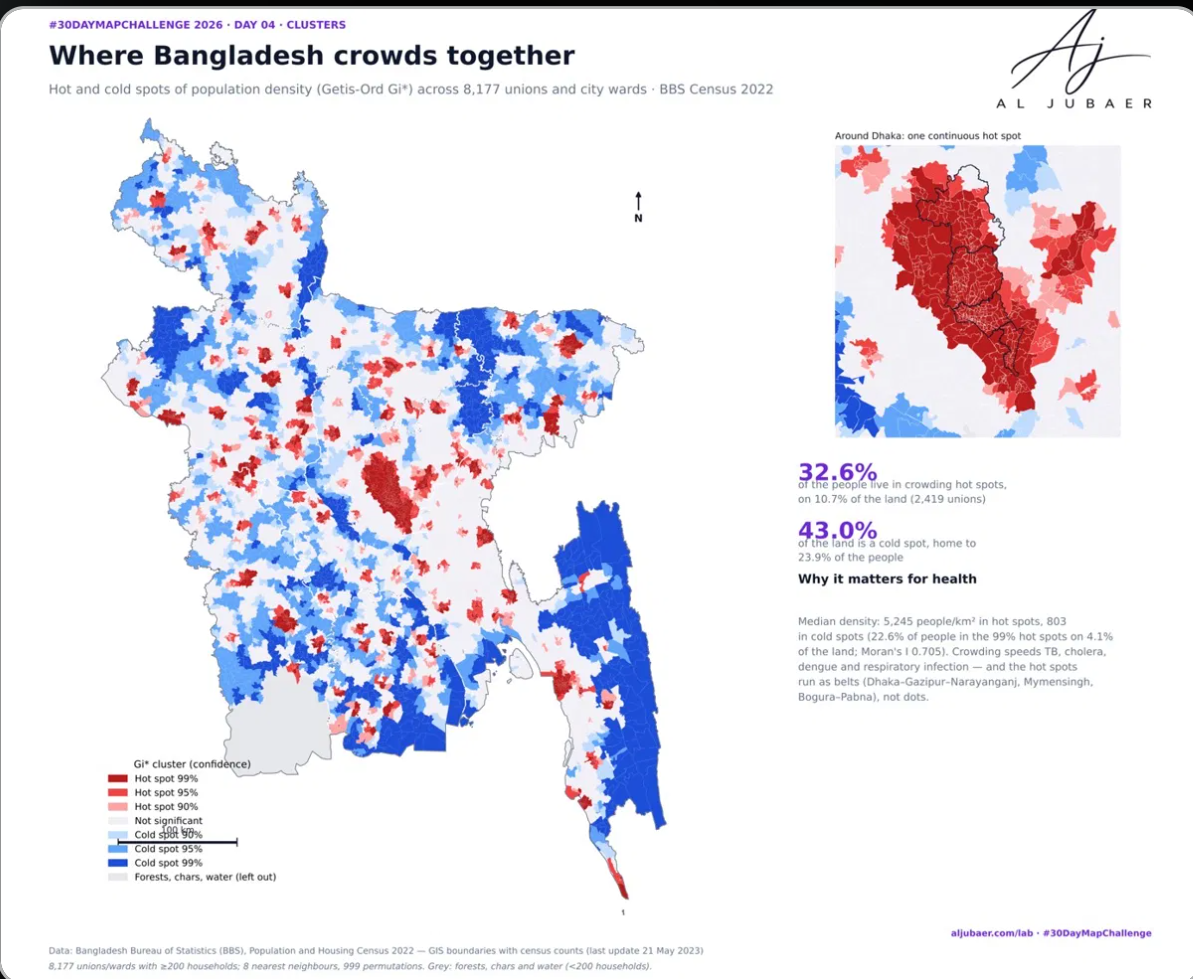
Three kinds of clusters in the 2022 census, union by union. Crowding: 32.6% of Bangladeshis live in density hot spots on 10.7% of the land. Leaving: emigration clusters home to 18.3% of residents send 50.9% of everyone living abroad — and 62.7% of them are also 'missing men' clusters, at 86.2 men per 100 women. Cities: by the UN rule 46.1% of people live in urban clusters, twice the 23.6% inside official city and municipal limits; one Greater Dhaka cluster holds 41.0 million.

Write-up
The question
Where do Bangladesh's people, its emigrants and its men cluster — and how far do the real clusters run beyond official city limits?
Data
Bangladesh Bureau of Statistics (BBS), Population and Housing Census 2022 — GIS boundary layers with census counts (unions/wards and villages, city corporations, municipalities), last update 21 May 2023, supplied files. Population as attached to the layers (165.5 million, before the post-enumeration adjustment). NRB = members of the household living abroad. Cluster significance is pseudo-significance from permutations, not corrected for multiple testing.
Methods
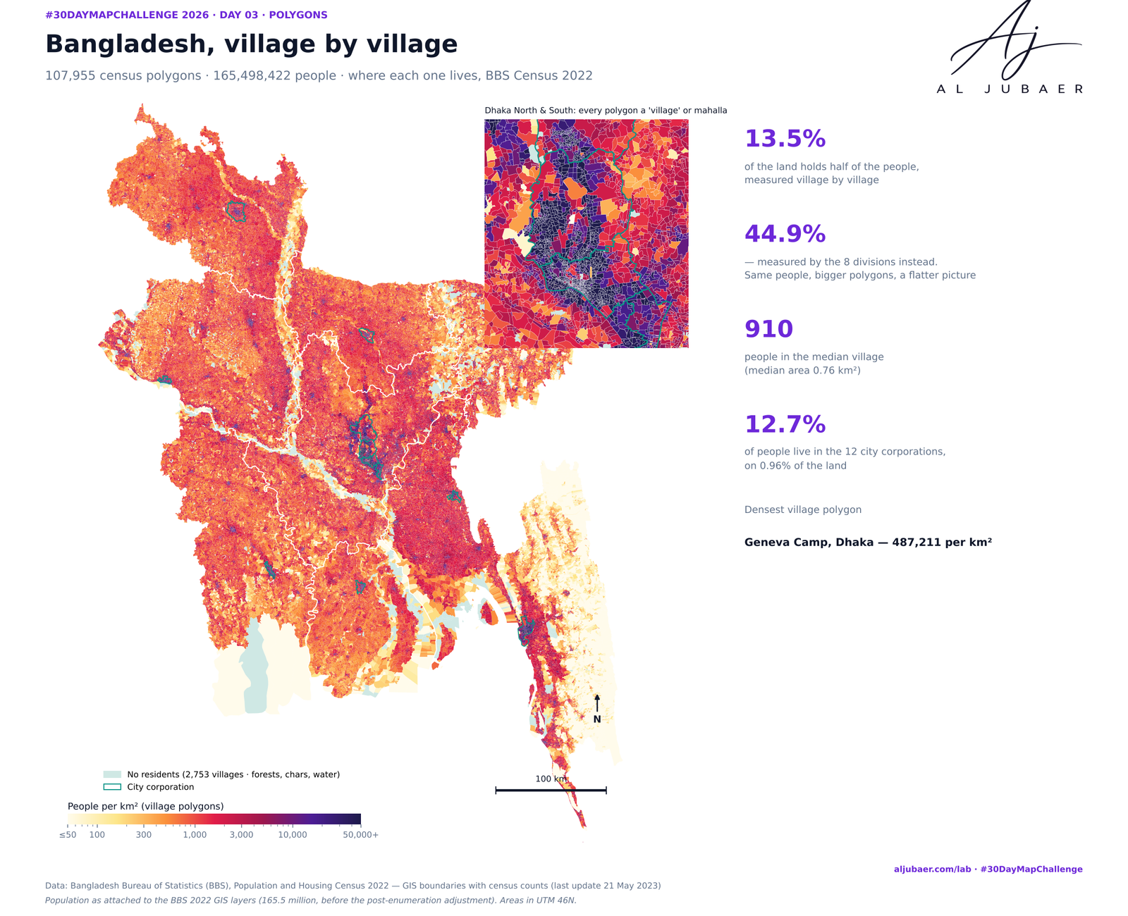
- Data: BBS Population and Housing Census 2022 GIS layers (the Day 3 files) — 8,202 unions and city/municipal wards and 107,955 villages, with population, sex, household size and people abroad (NRB). Village populations corrected for double counting (Day 3).
- Units: 8,177 unions/wards with at least 200 households; 25 (Sundarbans, chars, forests, water) are left out and shown in grey.
- Neighbours: the 8 nearest union centroids (k-nearest neighbours, row-standardised) — every union has neighbours, including islands and chars.
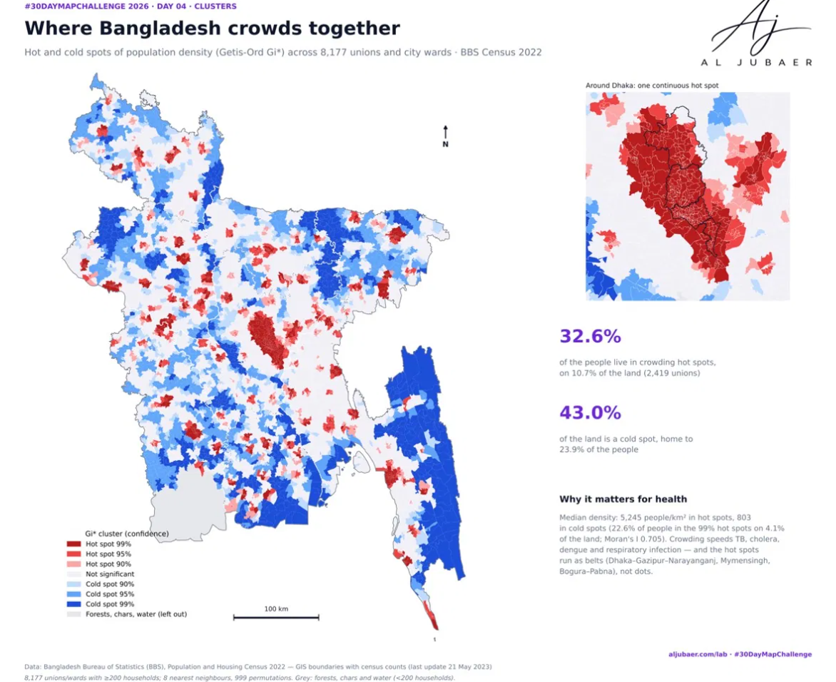
- Crowding hot spots: Getis-Ord Gi* on log10(people per km²), 999 conditional permutations; hot / cold at 90, 95 and 99% pseudo-significance.
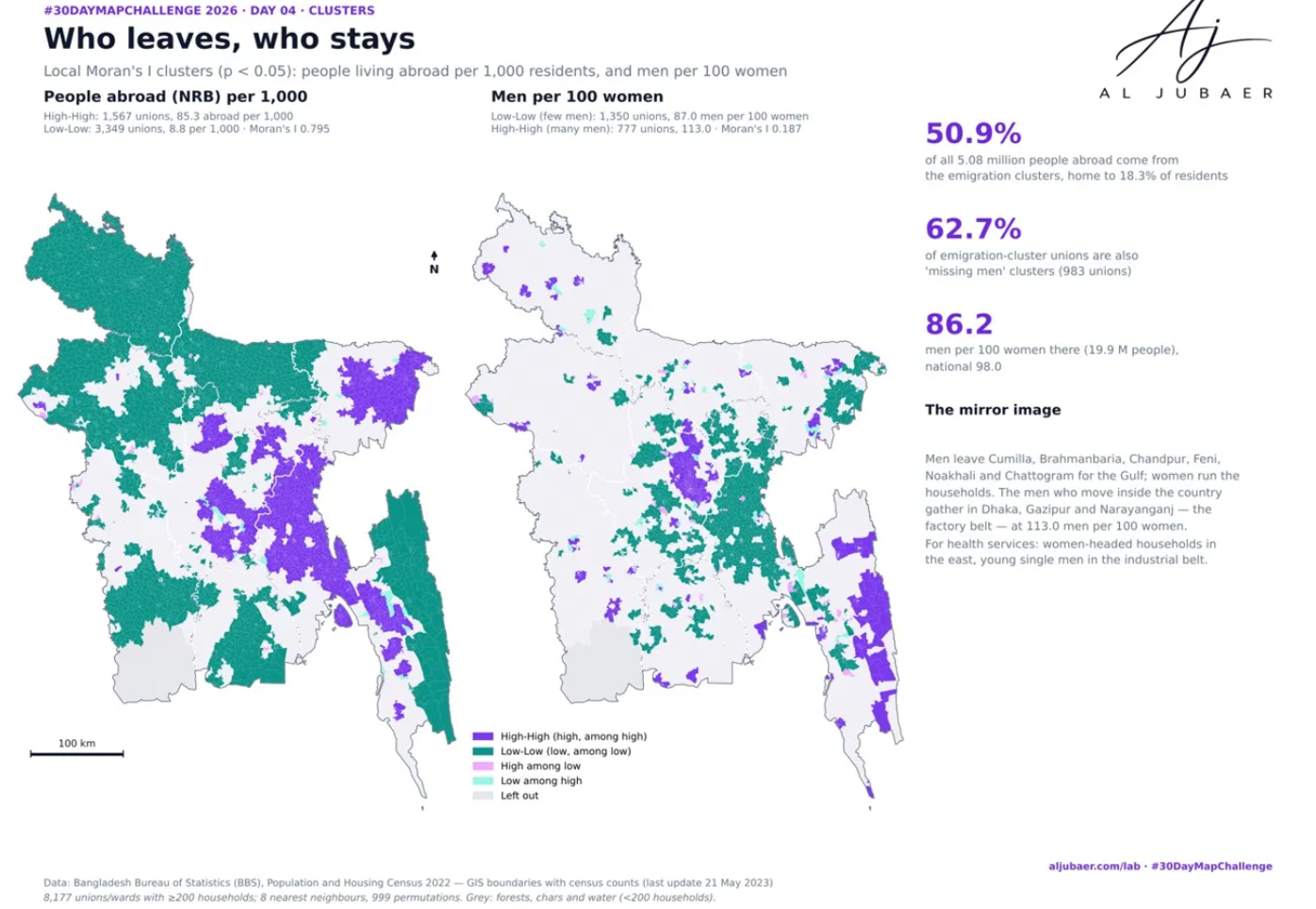
- Who leaves, who stays: Local Moran's I (LISA) on people abroad per 1,000 residents and on men per 100 women, 999 permutations, p < 0.05; High-High, Low-Low and the two outlier types. Global Moran's I reported for each variable.
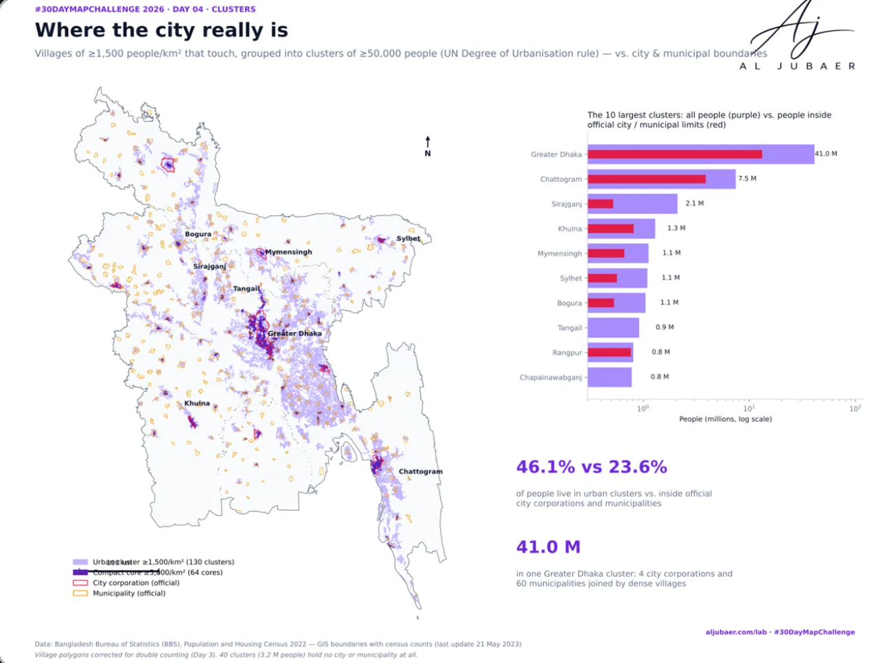
- Where the city really is: villages with ≥1,500 people per km² merged with touching neighbours (150 m buffer); merged patches with ≥50,000 people are urban clusters — the UN/EU Degree of Urbanisation rule applied to census polygons instead of a 1 km grid. A stricter ≥5,000 per km² cut gives the compact cores. Clusters are named after the city corporation or municipality inside them.
- Python: GeoPandas, PySAL (libpysal, esda), Matplotlib. Web map: TopoJSON in Leaflet on open basemaps. Analysis in WGS 84 / UTM 46N.
Findings
1. Crowding clusters: 2,419 unions form density hot spots — 32.6% of the people on 10.7% of the land (median 5,245 people/km²); the strongest (99%) hold 22.6% of people on 4.1%. Cold spots cover 43.0% of the land with 23.9% of the people. Moran's I of density: 0.705.
2. Emigration is the most clustered thing in the census (Moran's I 0.795): 1,567 High-High unions — Cumilla, Chattogram, Brahmanbaria, Sylhet, Feni, Chandpur, Noakhali — average 85.3 people abroad per 1,000 residents and account for 50.9% of all 5.08 million Bangladeshis abroad. The Low-Low belt across Rajshahi, Rangpur and Mymensingh averages 8.8.
3. The missing men: 62.7% of the emigration-cluster unions (983 unions, 19.9 million people) are also low sex-ratio clusters — 86.2 men per 100 women, against 98.0 nationally.
4. The mirror image: 777 male-heavy clusters around Dhaka, Gazipur and Narayanganj — the garment and industrial belt — average 113.0 men per 100 women.
5. Where the city really is: 130 urban clusters hold 46.1% of the people on 13.0% of the land — twice the 23.6% living inside official city corporations and municipalities. 40 clusters (3.2 million people) contain no city or municipality at all.
6. Greater Dhaka is one continuous cluster of 41.0 million people joining 4 city corporations and 60 municipalities; its compact core (≥5,000 per km²) alone holds 14.9 million at 33,222 people per km², with 116.4 men per 100 women.
7. For public health: the crowding hot spots are where TB, cholera, dengue and respiratory infections spread fastest; the emigration clusters are women-headed households living on remittances; the male-heavy belt is young single workers. Each needs a different service model.
 Web map & dashboard
 Map
 Web map & dashboard
 Map